The Clear Creek Trail, Clear Creek Connector, James Lee Loops and Jacks Valley Loop currently make up the Clear Creek Trail System. All are open to hikers, mountain bikers, equestrians and dogs. The Clear Creek Trail is about 22 miles long. The upper section begins at the Spooner Summit Trailhead behind the restroom on the south side of Highway 50. The lower section begins at the James Lee Park Trailhead. Access via the Clear Creek Connector is 2 miles long from the Clear Creek Connector Trailhead. The other two access points are from the Jacks Valley Road and Jacks Valley School Trailheads. These two trailheads along with the James Lee Park Trailhead provide access to the shorter James Lee Loops and to the longer Jacks Valley Loop which overlaps much of the Clear Creek Trail.
Ecological Fun Fact!
This trail passes through a great diversity of habitats, from sagebrush scrub around Jacks Valley Road to Jeffrey Pine forest near highway 50, as well as intermittent wet meadows and aspen stands. In the spring, at the lower parts of the trail, you may see the small yellow flowers of Carson Valley Monkeyflower which only grows in and around this valley. Higher up, look for other blooms including Wood’s Rose (five-petaled pink flowers on a bush), Mule’s Ears (big yellow flowers with furry leaves), and Phlox (low growing, white or pink flowers with five petals).
Clear Creek trail map provided by Carson Valley Trails Association.
Segments of this trail traverse private land; please be respectful and stay on the trail.
For more information on the trails check out the Carson Valley Trails Association trails overview.
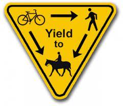
The trail can be quite narrow at times, yield to other users accordingly.
For equestrian specific information visit Nevada Horse Trails!

For more information regarding trail closures, visitor resources and recreation regulations please visit the US Forest Service website, or contact:
For more information regarding local trail conditions and volunteer opportunities please visit the Carson Valley Trails Association website, or contact:
US Forest Service - Carson Ranger DistrictJames Lee Park Trailhead:
Parking is available in the marked stalls that lead to the ballfield and cul-de-sac. Equestrian parking is not allowed in the park.
Jacks Valley School Trailhead:
A large dispersed area where equestrians currently park on the north side of the fenced solar panel area, and autos generally park on the south side near the kiosk. Parking is not allowed on the pavement.
Jacks Valley Road Trailhead:
A long pullout for about 12-15 autos along the north side of Jacks Valley Road located 0.3 miles west of the school. Equestrian parking is not available.
Clear Creek Connector Trailhead:
Although not a formal trailhead, parking is available for about a half dozen autos either next to the flood detention basin or along the shoulder near the interchange tunnel. From here, the trail begins directly on the south side of the parking pullout area.
Spooner Summit Trailhead:
Located on the south side of Highway 50. Horse trailers can sometimes park here if space is available; however, trailers can also park along the large pullout shoulder directly west of the Spooner South Trailhead entrance, or by parking at a dirt pullout location a quarter mile east of Spooner Summit on the north side of the highway.
Bear activity is high in this area. Keep (people) (pets) (property) safe. Keep bears wild. For more information on the BearWise campaign, visit the Recreate Responsibly page, or click on this link to learn how to be BearWise in the outdoors.
Success! A new password has been emailed to you.
The best part of this trail… The views!