❄️Winter is here! Check out the latest snow fall and weather reports from NOAA ❄️

Winnemucca Bloody Shins Mtn Bike Trail

Trail Uses
Hiking Mountain biking E-biking Horseback riding
Location
Humboldt County
Length
27.00 miles (Network)
Difficulty
Easy, Moderate, Difficult
Town
Winnemucca
Surface
Dirt
Pets
Permitted
Fees
No
Other Activities
UTV/Jeep Driving ATV Riding
There are no photos saved for this trail yet.
A large network of trails that is a beautiful and memorable place to explore any day of the year.
There are no photos saved for this trail yet.

Description

The Winnemucca area boasts a network of 26 diverse multiuse trails, among which the renowned Bloody Shins Trail takes the spotlight. Spanning 12 to 17 miles, its length depends on the chosen loops, offering distinct beginner, intermediate, and advanced segments.

For both hikers and horseback riders, an abundance of trails and rock gardens beckon exploration, rendering the possibilities seemingly boundless. Whether following established routes on the trail map or forging a personal adventure, the choices are yours to make.

These trails encompass a variety of terrains, featuring single tracks, double tracks, and dirt roads. Some align fully or partially with a connecting OHV trail system, adding to the versatility. It's worth noting that signage within the trail system can be sparse, adding an element of exploration to the experience.
Other Information

  • The trail system is not shaded, so be sure to time your recreational activity accordingly. 
  • There are no amenities in the parking lot.
  • Be prepared and pack plenty of water, snacks, and sunscreen. 
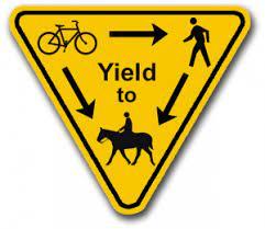
  • Please yield accordingly to other recreationalists.


Visit the City of Winnemucca website...


Trail Manager

For additional information, visit the BLM - Winnemucca District website, or contact:

Bureau of Land Management - Winnemucca District Office

Bureau of Land Management - Winnemucca District Office
5100 East Winnemucca Blvd.
Winnemucca, Nevada 89445
Phone: 775-623-1500
wfoweb@blm.gov
View website

Download

Download map files for your own use.

Working with Downloaded Files

Recreate Responsibly

Plan Ahead and Prepare
Avoid hypothermia, even in warm weather, by limiting your sweat and exposure to cold water. Bring warm and dry clothes in case the shivers set in.
Legend
|
Hide All

Trailhead Information

The main parking area and trailhead is located east of downtown Winnemucca on Kluncy Canyon Road. From I-80, take exit 178 for NV-289. Turn right onto NV-289 (East 2nd Street), then immediately take a left onto East Winnemucca Boulevard. Go 0.8 miles then take a right on North Highland Drive. After 0.4 miles, turn left onto Kluncy Canyon Road. Go 1 mile to the intersection with Rim Rock Road. The parking lot for the trailhead is a large dirt turn out, where Kluncy Canyon Road turns into a dirt road.

Click on a parking icon to get custom directions
Please Log In or Create Account to add comments.
SHARE THIS TRAIL
PRINT THIS TRAIL

Add Trail Log

Please wait…
Facebook Instagram Twitter YouTube
Join In on the Fun!
Log in or create an account below to unlock all the great features of Nevada Trail Finder: keep track of trails you want to do, preserve memories of trails you’ve done, earn badges, and more!
Your log in attempt was not successful. Please try again.
    Lost your password? Reset your password
    Don't yet have an account?
    There was an issue with your submission. Please try again.
      * Indicates required field
      Already have an account? Login here
      Enter your username, and we will send you a new, randomly generated password to your email account.
      There was an issue with your submission. Please try again.

        Success! A new password has been emailed to you.

        Log in now

        Please wait…